Venue
More about the venue, Westwood Hills Nature Center.
Introduction
Westwood Hills Nature Center is a 160-acre natural area featuring marsh, woods, and restored prairie. It is located west of Minneapolis in the City of St. Louis Park, about 4 miles from our home in Hopkins.
HGA Architects designed the new interpretive center
History
In 1890 local businessman Thomas Barlow Walker and his colleagues began purchasing land in the area of St. Louis Park for a business development intended to attract new manufacturing industry to Minneapolis. The land in the area of St. Louis Park at that time was being used primarily for farming and dairy production. Nearby this early manufacturing development, Minnesota’s first 27-hole golf course was developed and opened for play in 1928.

In the mid-1950s when the golf course was no longer profitable, the owners began to develop the land, selling off lots, and building houses in the area. The City of St. Louis Park acquired land from Westwood Hills Golf Course in 1958.
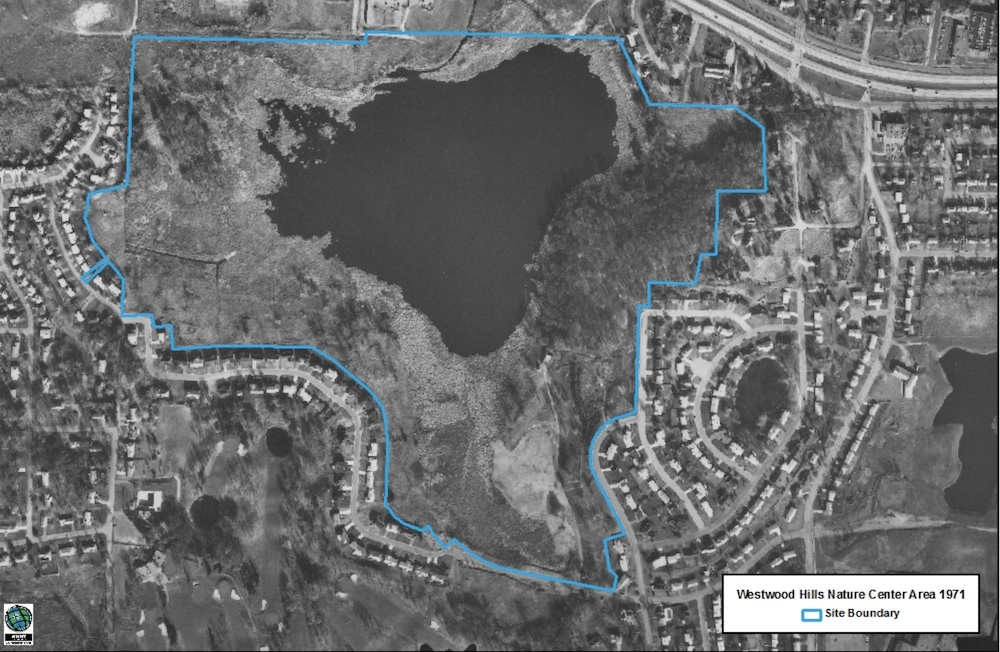
In 1959 during construction of some houses, a section of the drain tile broke that had previously kept the Westwood Lake basin drained. The lake began to fill over the following year. In 1971, the city began to explore the development of a nature center. A decade later, in 1981, the Westwood Hills Nature Center’s first Interpretive Center Building was opened, set back in the woods.

A new Interpretive Center opened in 2020 sited closer to the parking lot. We discovered it on one of our weekly hikes during the pandemic lockdown. The 13,500-square-foot building’s major sustainable features include a closed loop geothermal system for heating and cooling and a 122-kilowatt rooftop solar array to power the building. Over the course of the year, solar panels offset electricity used. These design features inspired us and when it came time to find a wedding venue, the choice was clear.
Westwood Hills Nature Center is managed according to a Nature Resource Management Plan prepared in 2017. The following sections are excerpts edited for brevity.
Geology
The Twin Cities terrain is shaped primarily by glaciers, both directly and indirectly. The area’s hills are largely glacial moraines — piles of sediment hundreds of feet high, bulldozed by advancing glaciers in the last ice age roughly 10,000 years ago. The historic bedrock surface influenced the way in which the glaciers and their associated meltwater streams shaped the landforms as they either planed or cut the bedrock respectively. These glaciers gave the region its current topographic character.
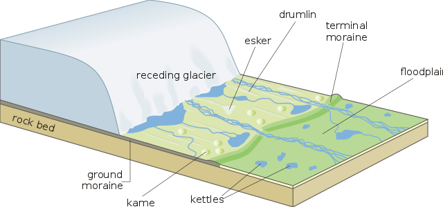
In the Twin Cities area, the Des Moines lobe, with drift generated from shale and limestone, advanced from the west and over-rode the drift contributed from the Superior Lobe that had advanced from the north where its sediments were derived from the Lake Superior region. The meltwater streams of the retreating glaciers deposited sand and gravel. The result were layers of different tills and a topography defined by both glaciers. The lakes and bogs of Hennepin County occur in depressions left by the melting of ice buried under sediments or were created by the collapse and settling of glacial outwash. Depth to bedrock varies in the vicinity of Westwood Hills Nature Center from 50-200 feet. At 114 feet above Westwood Lake, the terminal moraine on the eastern edge of the property is one of the highest points in St. Louis Park. This marks the maximum advance of the last glacier in the area.
Soils
The geologic origin of the soils on the slopes of Westwood Hills Nature Center are outwash deposits of sand, silty sand and gravel, overlain by a thin veneer of clay loam or silt. The outwash was laid down by meltwater streams originating from western Hennepin County and southern Anoka County. High grade sand and gravel deposits occur in several locations in St. Louis Park and several excavation sites were developed in the area. At the end of World War II there were eight gravel mines in operation in the city of St. Louis Park, some of which were still in operation into the 1960’s before the resource was depleted and the land given over for other forms of development. The gravel excavated from the local pits was used for construction and road work in Minneapolis and the surrounding area.
Vegetation
Westwood Hill Nature Center is a mix of open water, marsh, oak woodland, restored prairie, and oak savannah.
Oak Forest
The canopy and subcanopy of the oak forest is dominated by red oak, American basswood, hackberry, sugar maple, black cherry, green ash, and red elm. There is modest cover of several native shrub species including wild currants, brambles, prickly ash, and elderberry.
On the Northshore of Westwood Lake, mature cottonwoods are the dominant trees along the shoreline, forming a canopy over hackberry, boxelder, and silver maple. Islands of volunteer trees including boxelder, black willow, green ash, black walnut, and Russian olive have established in the altered habitat upland from the shoreline.
Shrub Carr
Along the southwestern shore, a shrub carr exists. A shrub carr is a wetland community dominated by tall shrubs with a ground flora dominated by grasses, sedges, and forbs typical of wet meadows. Common native shrub species that occur in this unit include elderberry, pussy willow, and red-twigged dogwood. Green ash trees are common scattered throughout the shrub carr. Red maple and silver maple have been planted along the boardwalk.
Pine Plantings
There is an altered woodland dominated in part by planted evergreen species with additional cover provided by native deciduous hardwood tree species. At least some of the evergreens were planted as long ago as 1960. However, the conifer planting has not been managed to attain a density that would support the healthy growth of trees. Many of the trees in the unit are crowded, with small diameters (dbh’s) and similarly stunted crowns.
Restored Prairie
Prairie Restorations, Inc. began the planning and implementation of the Westwood Hills prairie in 1978. Now 45 years old, the prairie is on an annual management plan. Prescribed burns are conducted periodically and invasive species are being managed with spot herbicide treatments. In 2009, the prairie was enhanced with the addition of wildflowers near the edge along the driveway. The prairie flora includes the native grasses big bluestem, indiangrass, switchgrass, sideoats grama, and little bluestem. Native forbs include hoary vervain, gray-headed coneflower, dotted blazingstar, wild lavender bergamot, common ox-eye, compass plant, and cupplant.
Westwood Lake
Westwood Lake is a DNR public waters. The open water or littoral zone of Westwood Lake is 42 acres in area with a maximum lake depth of 5 feet. Westwood Lake is in the Basset Creek Watershed. The watershed of the landlocked lake is 463 acres.
Wildlife
Westwood Hills Nature Center provides habitat for many animals, including deer, turkeys, turtles, fox, mink, owls, and other birds. At the interpretive center, you can view live animals, among them a flying squirrel, a chipmunk, a red-tailed hawk, an American kestrel and a barred owl.